Home
Home
 Me
Me
 Living
 Sport
Sport
 Work
Work
 Contact
 Germar's Monthly Updater
|
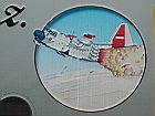
July 2007: Summit, Greenland
| ||||||||
| ||||||||
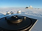
| In July, I traveled to Greenland to service a spectroradiometer of the National Science Foundation's UV Monitoring Network. The instrument is located at the top of Greenland's ice cap, at about 3200 m above sea level. The whole journey lasted only seven days but I was sitting in planes during six of those days. Getting there was not easy. It involved two flights on commercial airplanes from San Diego to Schenectady in Upstate New York; a flight with the New York Air National Guard to Kangerlussuaq at the west coast of Greenland; and another Air National Guard flight to the research station "Summit Camp." | ||||||||
| ||||||||
| ||||||||
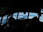
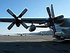
| Flying Air National Guard Flying with the Air National Guard is always an adventure. The unit uses Hercules ("Herc") LC-130 cargo aircrafts, which are designed to haul stuff rather than people. Seating is therefore a bit uncomfortable, to say the least. The upside is that the planes are flying low and visiting the cockpit is sometimes permitted. | ||||||||
| ||||||||
| ||||||||
| ||||||||
| ||||||||
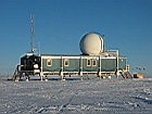
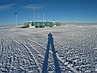
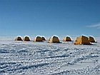
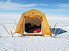
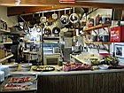
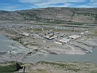
| At Summit Camp Summit Camp only consists of two buildings, the Big House and the Green House. The former includes a kitchen and dining area, and the latter berthing, laundry, and last but not least "my" instrument. The camp is so small that visitors, including myself, have to sleep in tents - despite temperatures of frequently below -20 �C! Life on camp is great. Due to the small (<15) number of people, everybody knows everybody, and all pitch in if help is needed. And there is gourmet food every day. Unfortunately, I was on station for only about 35 hours and worked 30 hours of those. | ||||||||
| ||||||||
| ||||||||
| ||||||||
| ||||||||
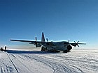
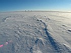
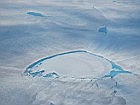
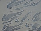
| Leaving the station was the biggest adventure. Two Hercs were supposed to arrive, the first to load cargo and the second to pick me and some other fellows up. Herc 1 landed, picked up cargo, took off, but radioed Herc 2 that the visibility is borderline and landing not advised. So Herc 2 turned around and we were stranded. In the meantime, Herc 1 was flying to GRIP2, an outpost further north where ice cores are drilled. Herc 1 made three attempts to land and drop off cargo, but poor visibility thwarted the plan and forced the plane to fly back to Summit and get gas. That was our chance to get out. We went on the plane and were ready to depart, but unfortunately one engine didn't start. What now followed was most impressive. A shaky step-ladder was put below the broken engine and an engineer worked for half an hour replacing a part, stoically ignoring the freezing temperatures. It worked, and we took off. But we still had the cargo. So we flew back to GRIP2 and managed to land on a poorly groomed runway. There was no time to stop the plane and unload the cargo with a forklift, like it is usually done. Instead, the back door was opened, the retainers of the cargo pallets were loosened, and - with the plane accelerating - the pallets started to move. It was quite a view to watch this type of "combat offloading." In particular the somersault of the last pallet (sized 3x3x2 meters) was quite spectacular. Now the plane was empty and we were about to take off. Unfortunately, the runway was so rough that we didn't get enough speed and had to abandon the start. Now the loadmasters worked like crazy to get the remaining cargo (which was basically five people and their personal belongings) as far back as possible on the plane to relieve weight on the Herc's front ski. This did the trick, and we finally took off and headed back to Kangerlussuaq. Flying over Greenland | ||||||||
| ||||||||
| ||||||||
| ||||||||
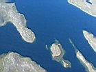
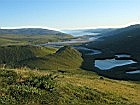
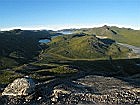
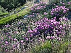
| Kangerlussuaq Back in Kangerlussuaq, I had a few hours to kill before boarding the flight back to the U.S. I borrowed a bicycle and headed into the wilderness. I decided to climb up Sugar Loaf, a 350-meter high hill north east of Kangerlussuaq. The view from the top was awesome, stretching from the town on one side to Russells Glacier on the other. Everything was green, proving that the name Greenland is indeed appropriate - at least during the short period of summer. | ||||||||
| ||||||||
|
Return to:
Last updated: 23 January 2016
|
||||||||